Ōtautau Events - Major floods affecting Ōtautau Township from 1878 to 1987:
Shared by
Central & Western Murihiku Southland Archive
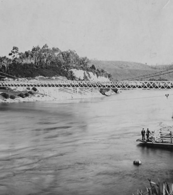
Ōtautau Events - Major floods in the Township from 1878 to 1987: IMAGES: Photo 1 - Ōtautau Hotel and Publican Nicholas Kelly on a donkey and others, in 1906 flood (Wrongly labelled in some other institutions as the 1913 flood). NLNZ have confirmed from items in their collection that this is definitely 1906. Image donated to the "Between River & Stream" Ōtautau history project by Peter Campbell, Public Domain Photo. Photo 2 - Intersection of Alderly & Main Streets, Ōtautau during 1913 flood, but unsure which one. A women sits on a horse in the floodwaters. Image donated to the "Between River & Stream" Ōtautau history project by Peter Campbell, Public Domain Photo. Photo 3 - Main Street, Ōtautau outside Bell & Thomas Motor Garage being run in the 'old' Town Hall, 1913 flood. Image donated to the "Between River & Stream" Ōtautau history project by Peter Campbell, Public Domain Photo. Photo 4 - Aparima River Flood of 1928, view of Yellow Bluff Bridge with a car and two women observing the floodwaters. Image donated to the "Between River & Stream" Ōtautau history project by Peter Campbell, Public Domain Photo. Photo 5 - Ōtautau Stream floodwaters at the bend west of North Ōtautau during the 1935 floods. Image donated to the "Between River & Stream" Ōtautau history project by Peter Campbell, Public Domain Photo. Photo 6 - Floodwaters over the Holt Park road, Martha Campbell (Peter's mother) on the horse, 1935. Image donated to the "Between River & Stream" Ōtautau history project by Peter Campbell, Public Domain Photo. Photo 7 - North Ōtautau flooding, Liemen Street under water during 1948. Image donated to the "Between River & Stream" Ōtautau history project by Peter Campbell, under CC BY licence. Photo 8 - Truck in floodwaters on Harbison Street, North Ōtautau, outside the old Maternity Home in 1948. Image donated to the "Between River & Stream" Ōtautau history project by Peter Campbell, under CC BY licence. Photo 9 - Main Street, Ōtautau, floodwaters outside the National Bank building, 1978 flood. Image donated to the "Between River & Stream" Ōtautau history project by Peter Gutsell, under CC BY licence. Photo 10 - Floodwaters over the road outside the Ōtautau Hotel, during the 1984 flood. Donated to the "Between River & Stream" Ōtautau history project by the Eden Family, Copyright to Ron Eden, used with permission. Photo 11 - Water over the bridge on Main Street heading north, Ōtautau, during the 1984 flood. Image donated to the "Between River & Stream" Ōtautau history project by Peter Campbell, Copyright unknown. Photo 12 - Floodwaters surrounding the Ōtautau School during the 1984 flood. Image donated to the "Between River & Stream" Ōtautau history project by Peter Campbell, Copyright unknown. Photo 13 - Ōtautau from the air, showing the extent of the floodwaters during the 1984 flood. Image donated to the "Between River & Stream" Ōtautau history project by Peter Campbell, Copyright Unknown. Photo 14 - Work being undertaken on the river banks along Ōtautau Stream during 1987, before the old Mill was demolished to make way for the new floodbanks. Image donated to the "Between River & Stream" Ōtautau history project by Peter Campbell, Copyright Unknown. NOTE: if anyone knows who took any of the above more recent flood photos gifted by Peter Campbell (the 1984 ones in particular), please let us know and we can ensure they are identified by their photographer. We all know that Ōtautau is prone to flood and that there have been a number of large floods over the years. I myself knew of about 10 floods that affected the Township, but until researching the past floods for the early Ōtautau History book project, I had no idea there were nearly 30! The early settlers had quite a conundrum when it came to living by rivers. They had to have access to easy water for their household and stock needs, but this put them at risk of flood. For many, it was just a fact of life and they took the floods as just another trial of their pioneer lives. LIST OF MAJOR ŌTAUTAU FLOODS THROUGH THE YEARS: 1: February 1843 – although Ōtautau was not even thought of at this time, and Murihiku had not been sold yet, an even worse flood hit coastal Riverton settlers than later on in 1878. It is beyond a doubt that where Ōtautau sits today, would also have been badly affected by this. 2: Monday 12 August 1878 - called an old man flood, this was “the most severe flood to have occurred for many years” to hit the district, with Ōtautau being the worst flooded of all. The bridge approaches were damaged too. 3: Monday 30th September1878 – just over a month later, floods hit again even worse than last time. Timbers to repair the prior flood damage to the bridge were nearly washed away in the flood waters, but they were luckily rescued just in time. 4: 29-31 May 1886 - It was reported that along the Aparima River, “the country resembled an inland lake.” The river at Fairfax was higher than during the highest on record in 1878. 5: Friday 6th January 1888 - the flooding was described as the town, “having the appearance of a lake from the (Yellow) Bluff terraces to the highlands on the side.” The flooding was bad. 6: Tuesday 31 October 1893 - the town is reported as flooding once more, after 32 hours of continuous rain, with the township stores and dwellings underwater on the Main Street. 7/8: In both July and October 1896 - just years later, the township floods yet again, twice. 9: November 1899 another flood comes through the Ōtautau Township causing damage. NOTE: In 1900, the Wallace County Council submitted plans to erect embankments along Ōtautau Stream from the bridge, across the terrace and the south side. The belief was that there was no danger of another imminent heavy flood within the next few years and that raising the bank to a couple of inches above the highest known flood level of the past, would suffice. They could not have been more wrong about this! 10: Wednesday 9 December 1903 - Ōtautau Stream once more broke its banks and flooded the town. The rate the stream rapidly rose to its height, despite the new banks, was noted. The stream was higher than the January 1888 flood, which was the highest known until now. 11: Wednesday 2 March 1904 – the second flood in 3 days in Ōtautau was worst, which new banks erected failed to protect them from, and which were in fact blamed for some damage. Earlier flooding of the Aparima on 28/29 February contributed to this flood a few days later. 12: Night of Friday/Saturday 21 April 1906 - Ōtautau township once more flooded severely, despite the attempts to keep the waters our with embankments along the Ōtautau Stream. One of the funniest flood photos ever was taken in this, of Publican N Kelly on a donkey. 13: Friday 27 August 1909 – another flood after 36 hours of continuous rain, “the highest in years” flowed into Ōtautau after embankments built to protect the town gave way in places. NOTE: This led to more protective works proposed in 1910, to help protect the township and especially Ōtautau Stream from overloading and flooding the residential and business areas. A loan was taken out and a special rate claimed against the residents to pay for the cost of it. 14: Monday 16 September 1912 - swelling of both the Aparima and Ōtautau Rivers, these overflowed and covered the local country with flood waters. This flood of September 1912 was said again, to be one of the biggest floods of recent years in the district and for Ōtautau. 15: Fatal Flood of 1913 - After massive rain which fell from 27 to 29 March 1913, the largest and “most disastrous flood since the big one of 1878” was to befall Murihiku Southand and in particular, Ōtautau and Lumsden. Again, the flood waters broke on a Friday, which seems to be a fateful day for floods in Ōtautau. Initial news got out to the nation was that flooding had occurred, but in the days that followed, much more information on the severity of the flooding came in from the experiences of those in the town itself and the news was not good. It was not just rain alone to cause the flooding, the temperature was so warm that all the snow was melted as well, which quickly caused a mass of flooded rivers and streams. Stock and crop losses were severe and there was even the loss of a farmer, David Younger. 16: Thursday 30 October 1913 – just months later, once again Ōtautau was under siege of flood. News came in from Ōtautau that both houses and business premises are inundated with flood waters once more with flood waters rising to “knee-deep” in the Main Street. 17: Thursday 7 September 1916 - there were more floods at Ōtautau, although not quite so severe as the last. After rain and then heavy snow fell over two days, the Aparima River was a, “Seething mass of water surging over the shingle with a continuous roar,” with both the Ōtautau and Opio in flood. Banks again gave way and flooded North Ōtautau and also the Main Street, but luckily, not badly. Sadly, one young man was not so lucky. William Pay of Bayswater was drowned along with his horse in the flood, after driving a dray into a ditch. 18: Sunday 27 May 1917 - sees yet another flood into Ōtautau. After heavy rain throughout most of Friday, Saturday night and into Sunday, the Aparima River looked likely to flood and did as promised. Thankfully new flood prevention banks on the river at Bayswater served well and protected wheat crops there, but higher up the Aparima broke her banks badly and also just above Ōtautau. As usual, the breaks affected North Ōtautau township woefully. 19: Tuesday 6 September 1927 - after a 48 hour period of continuous heavy rain, “one of the greatest floods in the history of the province (of Southland)” was underway. Snow falling in the higher regions increased the flooding as this melted. There was bad flooding in Ōtautau with the Main Street under water and many of the buildings flooded. The townspeople spent much of Tuesday night rescuing everything in the floodwaters reach and then on the Wednesday, all shops were shut and no-one was working, due to the state of the floods. 20: November 1928 – reports of recent protective works by the Ōtautau River Board are said to have proved “excellent” for drainage after recent floods, even though still incomplete. A photo of the Aparima River in flood at this time can be seen in the images shown here. 21: Tuesday 18 June 1935 - floods hit again. Heavy rain and melting snow caused very bad flooding in Ōtautau, with more than a few houses suffering from being flooded. The water spilled over at the bridge and spread to the township, but did not run down the Main Street. However, the township of North Ōtautau was hit with flooding as can be seen in photos. 22: Tuesday 15 October 1946 - more serious flooding is again reported at Ōtautau. Over 20 houses in the north of the town were evacuated overnight as the Aparima River poured over the flood embankment. Unfortunately not only did these fail to prevent the flood, but they also acted as a buffer to keep water dammed against the stop banks of the Ōtautau Stream. At this point, it seemed that Tuesday was the day that the floods would mostly hit Ōtautau. 23/24: 14 December 1948 - twice in just three days residents of North Ōtautau had flooding there with some homes affected. In at least two incidences the water was flowing not just in the back door of homes, but also out the front. The flood peak was recorded as reaching the 10ft mark at Aparima bridge, in North Ōtautau it was 9’ 6” past or nearly 2m past normal. 25: Wednesday 20 November 1957 - more disastrous floods reported. These did not do so much damage to the town itself, but the countryside areas around the town reported many deeply scoured paddocks and roads, flattened crops, submerged hay and lucerne stacks, silt covered pastures and broken and tangled fences. There were also significant stock losses. 26: Monday 31 October 1977 – Southland’s three main rivers broke their banks. It was said to be the worst flooding in Southland since a previous large flood in 1968. Not only that, but this flood followed another in May earlier the same year, which was also responsible for killing thousands of head of stock across the region. The floods of 29-30 October 1977 were recorded as being three metres above normal at Ōtautau. No other information is available. 27: Saturday 14 October 1978 – just a year later, a Civil Emergency was called for Southland as the region flooded, this lasted until 17 October with flood water levels at Ōtautau Stream recorded as being 2.78m compared to a normal water level of 1m. There was not much reported in the news about the flooding in Ōtautau at this time as other places flooded worse, but photos from this flood show the water was right down the main street and affecting many buildings. This flood appears to have been worse than the one in 1977. 28: Friday 27th January 1984 – so called ‘Black Friday’, the worst flood ever on record for Ōtautau was unleashed. This was so for the whole of Murihiku Southland, although the Central Western township of Ōtautau had a worse time than most, due to heavy localized rain. Over 125mm of rain fell in just 6 days and there was nearly 100mm of this on the 27th itself. Over 300 people in the township were evacuated to higher ground and a state of Civil Emergency was called, with many more choosing to leave as a precaution. Such was the state of the flooding that this Civil Emergency lasted until 9th February. While floods themselves were frightening and fraught with danger, the aftermath of the floodwaters and the sodden homes and businesses were the worst part for many. Some, especially the elderly, were both badly affected and under-insured. While the emotional and physical toll was beyond belief, some relief was at hand from the Red Cross and Lions. The local Council and other community organizations put in appeals for help for its citizens. The clean-up from this flood was at the time calculated to be around $300,000 which was a truly vast amount for such a small town. Photos show the severity of the flood. 29: Tuesday 10 March 1987 – Just three years later, there was a repeat performance for much of the Southern region along with the township of Ōtautau, and although not quite as severe, many were flood affected yet again with many people being evacuated. Flooding was compounded by the fact repairs had still not been completed since the previous flooding. NOTE: it was only after this, that Government funds for the stop-banks that still protect the town today, were given to the Ōtautau township to protect it from these kind of floods. They were specifically designed to control the flow of water down both the Ōtautau Stream and the Aparima River, with the water being able to spill over north of the township into farm land to relieve pressure on the banks in the township itself. We have seen these in action, especially over the first weekend of July 2023, when on 3 July the river peaked at 4.021m which was 2.621m above normal and the banks held the water from Ōtautau township, although we saw spillage at the Ōtautau Stream bridge north west of town, which flooded the Ōtautau-Tūātapere Road and inundated farmland across the flats here and elsewhere. Information above is researched by and copyright under a CC BY Licence to “Between River & Stream”, early history of Ōtautau book, and is kindly gifted by that project to our online community archive so everyone can view it. If you or anyone you know has any more photos, information or accounts of the many floods in Ōtautau during the years, on any aspects of flood works that took place here in the township or local area, please do share these in the comments section. You can do this by making a comment in the space provided under the image page. Please let us know if you have more photos, as they add the history of the township and district.
Ngā whakamārama
Details
-
Title
Ōtautau Events - Major floods affecting Ōtautau Township from 1878 to 1987:
-
Maker
Various, see photo information at top of page
-
Date made
1906-1987
-
Subject
Floods & Flooding, Ōtautau, Buildings, Bridges, Railways & Roads, Stock Losses, Rivers & Streams, Sandbagging, Civil Defence Emergency, Murihiku, Southland
-
Additional information
Digital only image in archive
-
Rights
Attribution (cc)
http://creativecommons.org/licenses/by/4.0/ -
View source record for this item
Kei hea tēnei taonga?
Where is this item held?
-
Additional information including high resolution images may be available.
-
Location
Main Rd, Tūātapere, next to the old Railway Station. We also belong to the internationally recognised 'Safe Space Alliance'.
Whare taonga | Organisation
Central & Western Murihiku Southland Archive
Ngā here ki runga i ngā whakaahua o tēnei taonga?
What can you do with images of this item?
-
You must check with Central & Western Murihiku Southland Archive to confirm terms of use and any attribution requirements, but this is our understanding:
-
Use for private study, research, criticism, review, or education
NZ Copyright law allows for the use of copyrighted works in specific circumstances. Consider what you can do under copyright law.
-
Share
You can share this image without further permission.
-
Modify or remix
You can modify, remix or add to this image without further permission.
-
Commercial use
You can use this image to make money.
-
Text adapted with permission from Te Papa and Digital NZ
Tāpirihia he kōrero anō
Improve this record
-
Can you help us? Share names, details and stories to help enrich the collection.