Port Craig - Maps of Sawmill License areas issued to Marlborough Timber Company, from 5.8.1918 onwards
Shared by
Central & Western Murihiku Southland Archive
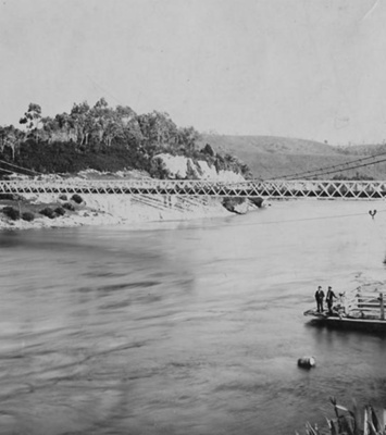
Port Craig - Maps of Sawmill License areas issued to Marlborough Timber Company from 5.8.1918 and later: This Port Craig entry is part of a large collaboration project between DOC Te Anau, DOC Murihiku, the DOC Hump Ridge Track Project Team and the Central & Western Archive - Murihiku Southland. Many more entries will be put online in the near future, so keep an eye out. Photo - Port Craig sawmilling site. Remains of old piles where Marlborough Timber Co workings were situated, as per above shown licenced areas. By Dallas Templeton 2023 (Image Licensed CC BY - if sharing, use Attribution) Document - Maps of Sawmill License areas issued to Marlborough Timber Company from 5.8.1918 and later. NOTE: Crown Copyright lasts 100 years, so Map 1 is now in the Public Domain. Map 2 should be considered to be within Crown Copyright and is shared here under a CC BY License. This file is also available as downloadable .pdf by clicking the icon under front image. Record is thanks to DOC, as listed. Transcript of these documents can be seen below the Port Craig heritage information here: PORT CRAIG HISTORY: Previously known as Mussel Bay, Port Craig - which was named after the two Craig brothers lives that were lost in its making - was the brainchild of the Marlborough Timber Company. After decimating native forests in the Marlborough Sounds and as other available forests of native bush to cut for logging were becoming much more scarce in places with access, when Māori land owners were found to be willing to sell the cutting rights to native forests at the west of Te Waewae Bay on the South West Coast, the company jumped at the chance to obtain these. While there was no virtually no land access, around 1916, the MTC started work on their new project at Port Craig, by erecting a wharf with a breakwater. Access was no hardship to the MTC, director Daniel Reese also had ships. It was not long before there was a large village set up in the backwoods bush. The mill was to finally open 22.09.1921. The Port Craig settlement was of a quite significant size, as it was very remote and had to service the needs of those working at the mill site. It is recorded that the Port Craig village settlement had a store, school, library, social hall, billiard room, cookhouse, store. Many houses and huts, accommodating the workers and their families. To start with, the men worked alone, but as time went on, wives and of course children, followed the men there. A large panoramic photo of the settlement and even more information, is recorded in these community archives, under entry CWA.019.005.003 In a bid to outdo all other national logging operations, the company had imported an expensive and enormous 'Lidgerwood' overhead logging plant, plus a large steam operated log hauler which weighed 80 tonnes, and this operated on overhead cables. An earlier trail which had been made years earlier, to give access to the Te Oneroa and Cromarty gold-diggings at Preservation Inlet, now laid the foundations for an over 14km tram track which ran from Port Craig to the Wairaurahiri River. With over 25km of tramways in total, being built through the bush for access to both the logging sites and the mill, many rivers (known as 'burns' in Scots), had to be crossed and many of these ran through the bottom of huge ravines, so an array of viaducts were built to accomplish traversing these. They were quite a feat all in themselves. The viaducts were, from small to large: 1. Edwin Burn - 50m L x 22m H 2. Francis Burn - 52m L x 14m H 3. Peter Burn - 59m L x 17m H 4. Percy Burn - 125m L x 36m H Photos of the largest of these, the Percy Burn Viaduct, can be found in these community archives under entry CWA.020.010.002 also under CWA.020.070.001 and a painting of this viaduct in CWA.012.014.037 But to get the logs off land and into the ships more easily, a large gantry was built in 1928 the company erected a huge gantry on the wharf, to feed logs to ships in the bay with an aerial loading system. We are fortunate to have photo of this, which can be seen in these community archives under entry CWA.019.005.005 The finances did not work out however. The Port Craig project was over invested and costs were much higher than planned. The logging was more difficult, the stands of forest required not as plentiful as had been imagined, and the large Lidgerwood plant was unable to operate effectively. Then it had boiler issues, so sadly, despite the huge expense of bringing it there, this was abandoned. Those running the Company invested more and more but in the end it was all lost. Increasing competition from the West Coast and shockingly low prices for timber, took the Marlborough Timber Company out. It is recorded that during 1928, the steamer Ōreti took 140 workers and their families away and another around 60 men trekked out of the bush on foot. After another brief trial to run the mill in 1930, it closed permanently. While some pieces of machinery were removed, much was left to the effects of nature, the remains of which can still be seen today, which includes the chassis of the famed Lidgerwood hauler and wharf crane. As for the buildings, the school, was refitted as a hut for hikers, and the 4 viaducts, which were re-decked to be used by trampers, have had a huge restoration project completed on them by the Port Craig Viaducts Charitable Trust, to make them safe to be used by walkers. These now make up part of the Hump Ridge Track. Along with these, some old wharf piles still remain, and the bakers’ oven and first mill. In a nutshell, a short history of the area is below, more elsewhere: 1916 - MTC start project by erecting a wharf with a breakwater 1921 - The mill was to finally open 22.09.1921, adjacent to the village 1923 - construction starts on Port Craig Viaducts, including Percy Burn 1924 - delays in the construction cause problems, as relayed in news 1925 - Percy Viaduct is finally officially opened for transporting timber 1928 - a large gantry was built on the wharf, to load timber onto ships 1928 - Port Craig Timber Company collapses, workers ship out 1930 - Port Craig Mill briefly opens, but closes again within months 1985 - work begins on researching the Port Craig site in earnest 1990 - Idea of Hump Ridge Track first discussed by Promotions 1994 - Percy Burn Viaduct successfully repaired and reopened 1999 - Viaduct land became Fiordland National Park, DOC control 2001 - Hump Ridge Walking Track including Percy Burn Viaduct opens 2013 - Entered as list No. 9234 on Historic Places Trust (Heritage NZ) 2013 - Structural decay noted on viaduct, closed for safety reasons 2018 - After a 5 yr closure, Percy Burn Viaduct is re-opened again 2024 - Percy Burn Viaduct set to become part of newest Great Walk Transcription - The digital record attached contains the following text: MAP1 - "Sawmill Areas Nos 630 & 631, BLK XIV, ROWALLAN DIST: The Marlborough Timber Co. McDonald. Approved. HWM... (hard to read), Chief Surveyor, 5.8.18 [1918]." The map itself bears the following Names/Sites & information, from L-R: "[area] 630, 200 acres, J Craig, Applicant. The Marlborough Timber Co. Tūātapere - Perservation Track. [area] 631, 200 acres, D Reese, Applicant. The Marlborough Timber Co. [area] 640 SM Site [area] 641 SM Site Port Craig Breakwater Iron Tube Proposed Scenic Reserve Te Waewae Bay" END Transcription - The digital record attached contains the following text: MAP 2 - The map itself bears the following Names/Sites & information, from L-R: "[no heading showing] From Trig Y Track to Preservation Inlet Sawmill site 640 - 19 acres, 3 roods, 39 perches Sawmill site 641 - 20 acres SA 631 Recreation Res - see plan 12 School 2 Site Sawmill [marked in blue highlighter] Port Craig Wharf Breakwater Iron Tube Orig Scale = 1:3980 [not sure if digits missing off side]" END More of these entries are coming in the near future. If you or anyone you know has any more information or photos to share or accounts of Mussel Beach, Port Craig, Marlborough Timber Company, the mill and workers during the years, please do share this with us in the comments section. You can do this by making a comment in the space provided under the image page. Or you can make contact with us as per the archive front page.
Ngā whakamārama
Details
-
Title
Port Craig - Maps of Sawmill License areas issued to Marlborough Timber Company, from 5.8.1918 onwards
-
Maker
Crown Lands, Templeton, Dallas, Unknown - someone at DOC (Department of Conservation)
-
Date made
19.03.1919
-
Subject
Port Craig, Mussel Beach (now Port Craig), Sawmilling, Logging & Forestry, Marlborough Timber Company, State Forests, Crown Lands, Cutting Rights, Occupation License, Sawmill Site License, Hump Ridge Track, Viaducts, Conservation, Department of (DOC), Hiking, Tramping, Hill Climbing, Bush Tramways, Wairaurahiri River, Waitutu Forest, Port Craig School
-
Additional information
Digital only image in archive Paper copy in files
-
Rights
Attribution (cc)
http://creativecommons.org/licenses/by/4.0/ -
View source record for this item
Kei hea tēnei taonga?
Where is this item held?
-
Additional information including high resolution images may be available.
-
Location
Main Rd, Tūātapere, next to the old Railway Station. We also belong to the internationally recognised 'Safe Space Alliance'.
Whare taonga | Organisation
Central & Western Murihiku Southland Archive
Ngā here ki runga i ngā whakaahua o tēnei taonga?
What can you do with images of this item?
-
You must check with Central & Western Murihiku Southland Archive to confirm terms of use and any attribution requirements, but this is our understanding:
-
Use for private study, research, criticism, review, or education
NZ Copyright law allows for the use of copyrighted works in specific circumstances. Consider what you can do under copyright law.
-
Share
You can share this image without further permission.
-
Modify or remix
You can modify, remix or add to this image without further permission.
-
Commercial use
You can use this image to make money.
-
Text adapted with permission from Te Papa and Digital NZ
Tāpirihia he kōrero anō
Improve this record
-
Can you help us? Share names, details and stories to help enrich the collection.