Fiordland History - Lake Gunn through the eyes of the Stewart & Burnby Families
Shared by Central & Western Murihiku Southland Archive
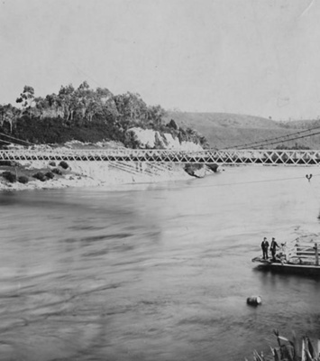
Fiordland History - Lake Gunn through the eyes of the Stewart & Burnby Families: BRIEF HISTORY OF LAKE GUNN - The first Europeans thought to have seen Lake Gunn was said to have been David McKellar (runholder) and George Gunn, on 9 June 1861. These two young men set forth from McKellar's runholding in Northern Southland in an attempt to find new pastures. Eventually arriving at Key Summit, they were to then come across views of the Eglinton Valley and the upper lakes there, one of which was given Gunn's name. They were the first Europeans to see the Hollyford Valley. Yet another lake in the vicinity bears McKellar's name. The STEWART & BURNBY FAMILIES - The Stewart family lived in Gore, where HD or Herbert Stewart was an electrician. One of his jobs was to connect electricity in out-of-the-way places, and he was to install the first electric lights at the Te Anau Caves! Herbert would take his family along with him while he went away to work sometimes and while on these trips, they would set up camp and go off tramping whenever possible. His daughter Carley grew to have a deep love and knowledge of the Fiordland area. When she later married George Burnby, the family moved into the area. Descendants are still living there. IMAGES: 1 - Lake Gunn from 1945-46, taken by Carley Stewart as a teenager. 2 - Taken at the same spot as above, but about 1956. Unknown woman with Stewart and Rozanne Burnby (children of Carley Burnby, née Stewart) NOTE: This photo has been taken off a slide and sent to us by the family, we are attempting to access the original so we can copy in high resolution. 3 - The first plane on Lake Gunn. This is apparently a Widgeon, but we don't know any more about it, can you help us with more information? NOTE: This photo has been taken off a slide and sent to us by the family, we are attempting to access the original so we can copy in high resolution. 4 - View of Lake Gunn, taken much later, but the scenery is still stunning. 5 - Lake Gunn with the view into the Melita Valley, taken in later years. The above photos are licensed CC BY. Most are believed to have been taken by Carley Stewart (later Burnby) from the time she was a teenager on trips up the Milford Road with her father during the mid 1940's, through to when she married George Burnby and they moved into Knob's Flat in the 1950's, then later Cascade Creek and finally settling in Te Anau. The donor of these photos from the Burnby family, says that their parents and grandparents have many memories of early times in Fiordland. They also wish to share these photos and stories with us all. More photos of the family and nature are in our online collections, and many more are to come. THE WIDGEON: On doing some research on this amphibious plane, it was most probably a Grumman G44A Super Widgeon, owned once upon a time by ground breaking 'Queenstown - Mount Cook Airways', formed in 1935 by a man called Wigley. The company had several name changes and was to operate charter flights around the Otago Lakes, Milford Sound and Mount Cook regions, until being suspended by World War II. They were to resume flying operations again in 1952 but in 1954, the now named 'NZ Aero Transport Company' was reformed as 'Mount Cook Air Services Ltd', and their role was to specialise in scenic flights, agricultural work and rescue missions. It is thought that this plane was operated by them at the time the photos were taken. But if anyone can verify any of these details, we would appreciate it. The plane is now recorded as being restored and operational, based in the North of the country, at KeriKeri in Te Tai Tokerau, near the Bay of Islands. SOME EARLY HISTORY: Te Rua-o-te-moko - to Māori, Fiordland is known as Te Rua-o-te-moko, A place of towering peaks and plunging valleys, a place where light and shadow create beauty and intrigue. This is certainly an apt description. Few Māori were permanent residents of the region, but well-worn trails linked seasonal food-gathering camps. Takiwai, a translucent greenstone or New Zealand jade, was sought from Anita Bay and elsewhere near the mouth of Milford Sound, according to records researched for this entry. Explorer and future Prime Minister Thomas Mackenzie had suggested in 1894 that the Fiordland region be declared a national park. The creation of Tongariro National Park (23 September) gave impetus to efforts to preserve other scenic areas. But it was a few decades before this was to eventuate. In 1903, Southland Commissioner of Crown Lands John Hay, who as a younger man had produced a remarkable reconnaissance map of southern Fiordland, suggested that the West Coast Sounds be preserved as a national park. ‘The country is excessively rugged, and quite unfit for pastoral purposes.’ The area set aside the following year included the iconic Milford Track, Mitre Peak, the Sutherland Falls and the eponymous fiords (steep-sided valleys gouged out by glaciers that were submerged when the sea level rose). The first step in creation of Fiordland National Park was when on the 23rd February 1904, nearly 1 million ha of far western Southland and Otago was set aside as a national reserve in 1904. This became New Zealand’s largest national park in 1952. The inclusion of the Hollyford Valley, Waitutu Forest and Solander Island subsequently enlarged this area to 1.26 million ha. Fiordland National Park has well fulfilled Tourist Department head Thomas Donne’s 1903 prediction that ‘if carefully preserved’ it would become one of New Zealand’s ‘foremost attractions’ and ‘greatest assets’. It sure has, and at times it is a real balance between allowing tourists to see the wonders it shows with preserving delicate ecosystems found within this pristine area. The Fiordland National Park was officially constituted in 1952 and became a UNESCO World Heritage site in 1986. Today, the park is now part of Te Wai Pounamu or Wahipounamu in the South West New Zealand (The place of Greenstone) which also incorporates Aoraki/Mt Cook, Fiordland, Mt Aspiring and Westland National Parks. It is one of three World Heritage sites across Aotearoa New Zealand, and has been described as having 'superlative natural phenomena' and 'outstanding examples of the earth's evolutionary history'. But looking even further back, Fiordland had a very active past before any humans were ever to encounter it. Evidence of Indo-Australian and Pacific Continental plates continual crashing, can be seen throughout the majestic Ka Tiritiri-o-te-Moana/Southern Alps. Creating an almost spinal structure, the mountain range which extends the full length of the South Island, is 4,000 metres (2.5 miles) at its highest point, and fourteen fiords are carved out of the rocks along the Fiordland coastline, remnants of the ice ages. Fiordland or Te Rua-o-Te-Moko really does have to be seen to be believed. Archivists comment: At the CWA Community & Heritage Hub, operated by Central & Western Archive - Murihiku Southland, we have books, records and photos on the history of this area, lakes, mountains, tracks and more. CURRENT DAY - The old Lake Gunn camp is no longer open to over night stays. It is now patrolled and a chain across entrance. The nearest available camp ground is Cascade Creek and it is well sign posted, being the last campsite before entering Milford Sound. It is a very popular, scenic campsite next to Cascade Creek and is situated at the southern end of Lake Gunn. The large grassy area has 120 non-powered/tent sites and incredible scenery. There is also a Lake Gunn Nature Walk, which is a great experience of wild Fiordland, often considered to be one of the area's best short walks. You can meander through red beech forests, enjoying listening to the birdlife and maybe even being treated to views of it, and then there is the fabulous Eglinton valley. You can just imagine how the sight of this majestic place felt to those first explorers who came into this view, over 100 years ago now. Hopefully this entry will be added to as more information on the history comes to hand. If you or anyone you know has any more information or photos to share or accounts of Lake Gunn or the wider area of Fiordland or Te Rua-o-Te-Moko, please do share this with us in the comments section. You can do this by making a comment in the space provided under the image page. Or you can make contact with us as per the archive front page.
Ngā whakamārama
Details
-
Title
Fiordland History - Lake Gunn through the eyes of the Stewart & Burnby Families
-
Maker
Various, see photo information at top of page
-
Date made
1940's-1980's
-
Subject
Fiordland, Te Rua-o-te-moko, Western Southland, Great outdoors, Fiordland National Park, Outdoor Adventure, Eglinton Valley, Early Exploration, Early Travel, Tourism, Milford Road, Lake Gunn, Fiordland or Te Rua-o-Te-Moko
-
Additional information
Digital only image in archive
-
Rights
Attribution (cc)
http://creativecommons.org/licenses/by/4.0/ -
View source record for this item
Kei hea tēnei taonga?
Where is this item held?
-
Additional information including high resolution images may be available.
-
Location
Main Rd, Tūātapere, next to the old Railway Station. We also belong to the internationally recognised 'Safe Space Alliance'.
Whare taonga | Organisation
Central & Western Murihiku Southland Archive
Ngā here ki runga i ngā whakaahua o tēnei taonga?
What can you do with images of this item?
-
You must check with Central & Western Murihiku Southland Archive to confirm terms of use and any attribution requirements, but this is our understanding:
-
Use for private study, research, criticism, review, or education
NZ Copyright law allows for the use of copyrighted works in specific circumstances. Consider what you can do under copyright law.
-
Share
You can share this image without further permission.
-
Modify or remix
You can modify, remix or add to this image without further permission.
-
Commercial use
You can use this image to make money.
-
Text adapted with permission from Te Papa and Digital NZ
Tāpirihia he kōrero anō
Improve this record
-
Can you help us? Share names, details and stories to help enrich the collection.